


Wayviewer - offers navigation in Europe and North America without fees, subscriptions, and on-line costs. The route must be computed before departure on a PC or a Notebook. For it a MAP&GUIDE derivate, e.g. ADAC TourPlaner or MOTORRAD TourPlaner, or Microsoft MapPoint version 2002 and above is used.
Since MapPoint provides the route plans without the GPS coordinates of the turn points, it was necessary to develop a special MapPoint Add-in that determines the GPS coordinates and writes them together with the driving instructions into a file. This file is copied afterwards to the mobile phone.
When using MAP&GUIDE programs no Plug-in is required. The generated Palm DB files can be used directly without any modifications.
The Wayviewer application itself is used on the mobile phone. It was developed in Java based on the Micro Edition of the Java 2 Platform (J2ME). At present the English, the German, and the French versions of MapPoint are supported.
Wayviewer imports the route plans into an internal data base (RecordStore). There several route plans can be stored at the same time. At a time one route plan can be selected and step by step be displayed. The driving instructions are compressed by using Icons that a meaningful representation on the display of the mobile phone is possible.
The software steps the driving instructions automatically forward during approximation to the next turn point. Alternatively they can be stepped manually. In this case no GPS receiver is required. In the automatic case an appropriate voice output takes place, in order not to distract the driver. For a reasonable use of the voice output, a hands-free speaking system or a headset are recommended.
Compatibility
In principle Wayviewer can run on all mobile phones, which support CLDC 1.1 and MIDP 2.0 and which provide access to Bluetooth (JSR 82) or the serial interface (data cable). Alternatively an integrated GPS receiver can be used if it can be accessed using JSR 179. Furthermore it must be possible to access files either over the standard way JSR 75 or using a proprietary one.
In particular the Siemens mobile phones starting from generation 65 as well as Nokia and Sony Ericsson models are supported, which implement JSR 75.
# Bluetooth: S65, SK65, SP65, CX75, M75, S75, SL75, SXG75, Nokia 6230i, SE K750i and others
# Data cable: additionally C65, CX65, CX70, M65, SL65 among others
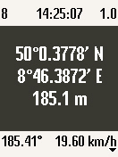
GPS receivers with Bluetooth or serial interface are supported, which provide the NMEA 0183 sentences GGA and VTG or RMC. That nearly all at the market available might be.
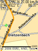
It is possible to do also without a connected GPS receiver. Of course in this case the software cannot step forward automatically. Nevertheless the route can be shown on the display of the mobile phone.
In the connection mode "Network/Internal" the Location API (JSR 179) is used. In this case no external GPS receiver is needed. In this case the location is determined by the GPS receiver or by the network provider. This functionality is obviously supported however in Germany so far by no provider.
Installation
# Unzip the file Wayviewer.zip on a PC and install the application according to the type of your mobile phone. Further references you can find in the FAQ.
# For file storage Wayviewer requires a folder Data inbox. This folder normally already exists on Siemens phones. On other mobile phones this folder must be created at a suitable location. Wayviewer looks for it in the roots of the file systems, i.e. also on a possibly existing memory card, as well as in the standard folders for pictures, tones, videos, and others. If it cannot be found, it will be created automatically in one of these folders.
The file system access is extremely restrictively implemented in the operating systems of the mobile phones for security reasons. On non Siemens phones the file system access might be refused by default without further inquiry to the user. Therefore please make sure to setup your security settings in such a way that the user is asked before file system access.
Usage
- Copy the text file generated with the MapPoint Add-in or the PDB file generated with a MAP&GUIDE program to the folder Data inbox. Please avoid umlauts in the file name since it may lead to problems on some mobile phone types.
- Select "Wayviewer" in the menu item "Applications" in the menu "My Phone", "Media Pool" or "Surf & Fun". In the case of frequent use it is advisable to assign a shortcut key to the application.
- Push "Options" and select the menu item "Import".
- Answer question "Modify file system? (O:/Misc/Data inbox/)" with "For session".
- Select appropriate file and if desired, delete it after the import. The progress of the import is indicated by a bar. The procedure can be interrupted at any time.
- Select the desired route.
- Afterwards appears the route summary containing the route name, the driving distance, the trip duration, the driving time, and the cost.
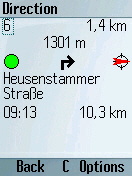
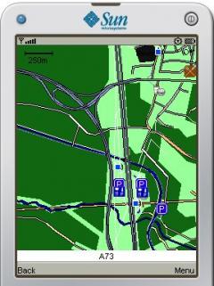
- After pushing "Continue" the first driving instruction appears. On the display are indicated the segment number, the length of the segment, the distance up to the next turning point (linear distance), the GPS status symbol, turn and direction symbols, as well as the strongly shortened textual instruction. At the end planned time and mileage are shown.
- The switching to the next driving instruction happens automatically controlled by the GPS receiver or manually by pushing "Continue". With the red key it is possible to return to the preceding menu option. With "Go To" in the "Options" menu one can go to a segment directly. In automatic mode during step up a voice or jingle output takes place depending on the option set.
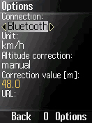
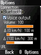
- The menu "Options" contains the following setting possibilities:
License key - License key for use after the test phase
Connection - "Bluetooth", "Cable", or "none". With "none" no GPS data are read. Step up has to be done manually. The GPS status symbol is not indicated.
Baud rate - Baud rate of the serial interface (NMEA default value 4800 Bit/s)
Voice output - Voice output if on, otherwise jingle
Volume Volume of the voice output
(0 km/h) - Distance, at which step up takes place at 0 km/h
(100 km/h) - Distance, at which step up takes place at 100 km/h
Font size - Font and symbol size of the driving instructions
Route language - Language of the used MapPoint version
URL - URL of the connection (informative only)
Before reaching the next turning the step up must take place in time, so that the driver can still execute the appropriate maneuvers. This threshold is speed-dependently adjusted with the options. The faster the vehicle moves, the rather is switched (linear correlation).
- In the menu item "Delete" imported routes can be deleted from the data base.
MapPoint Save Directions Add-in
The Save Directions Add-in is required to store a route plan including the GPS coordinates of the turn points into a file.
Supported are Microsoft MapPoint Europe and North America starting from version 2002. MapPoint 2004 and above are recommended. At present Wayviewer is able to interpret the route plans of the German, the English, and the French versions of MapPoint. If required it could be extended for the Italian and the Spanish versions.
Installation
* Unzip file DirectionsAddIn.zip.
* Start the Setup program and install DirectionsAddIn.dll.
* The successful installation can be checked in the menu item "COM Add-ins..." in the menu "Extras" of Microsoft MapPoint
Usage
* Generate driving instructions with Microsoft MapPoint.
* Call menu item "Save Directions..." in the menu "Extras".
* Change into a suitable folder, enter a file name and push "Save". Please avoid umlauts in the file name, since it leads to problems on some mobile phones types.
* If the pushpins were set imprecisely, change into a map view with less screen content (menu item "View Map StyleData Map"), delete the old pushpins, and repeat the generation.
· 15 days trial
What's New in This Release:
· Workaround for Sonim devices et al.
What's New in 3.3.1:
· Manual altitude correction for internal GPS receivers, Bluetooth URL editable.


Comments not found