


POIAlert indicates so called POIs (Points of Interest) by voice and display output. A POI can be any point with known GPS coordinates (danger place, restaurant, gas station etc.).
POI data can be loaded e.g. from several Internet sources. At present especially red light and speed cameras are supported.
At first POI data are imported from a file into an internal database (RecordStore). At runtime POIAlert loads all POIs within a radius of 5 km into a cache. During a journey the cache is being updated automatically. The current position is permanently compared with the positions of the cached POIs. This comparison depends on the current speed. As soon as the GPS receiver is near a POI, a voice and an optical information will be given. Since the voice output may be quiet depending on the type of the mobile phone, a hands-free speaking system or headset are recommended.
Compatibility
POIAlert runs on all phones which support at least CLDC 1.1 and MIDP 2.0 and allow access to Bluetooth (JSR 82) or the serial interface (data cable) and to the local file system (JSR 75). That applies to nearly all current mobile phone models. POIAlert requires significantly more CPU power than the other applications on this website. Since reliable comparisons of the CPU power of the several mobile phone types are not available, it is necessary to test POIAlert on the desired phone. Among others POIAlert has been tested successfully with the Nokia devices 6110, 6131, 6288, and N95. But a Siemens S65 is so slow that it can be used only with a small number of POIs.
GPS receivers with Bluetooth or serial interface are supported, which provide the NMEA 0183 sentences GGA and VTG or RMC. That nearly all at the market available might be. In the connection mode "Network/Internal" the Location API (JSR 179) is used. In this case no external GPS receiver is needed. The location is determined by the internal GPS receiver or by the network provider. The latter is obviously supported however in Germany so far by no provider.
Installation
* Unzip the file POIAlert.zip on a PC and install the application according to the type of your mobile phone. Further references you can find in the FAQ.
* For file storage POIAlert requires a folder Data inbox. This folder normally already exists on Siemens phones. On other mobile phones this folder must be created at a suitable location. POIAlert looks for it in the roots of the file systems, i.e. also on a possibly existing memory card, as well as in the standard folders for pictures, tones, videos, and others. If it cannot be found, it will be created automatically in one of these folders during the first access.
The file system access is extremely restrictively implemented in the operating systems of the mobile phones for security reasons. On non Siemens phones the file system access might be refused by default without further inquiry to the user. Therefore please make sure to setup your security settings in such a way that the user is asked before file system access.
Usage
# Copy the POI file to the folder Data inbox.
# Start POIAlert.
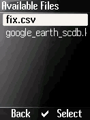
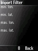
# Push "Options" and select the menu item "Import". Acknowledge security questions with "For session". After the desired file has been selected, a filter mask appears where minimal and maximal longitudes and latitudes can be entered. This especially makes sense if not enough memory for all POIs from the import file is available (error message RecordStoreFullException). The progress of the import is indicated by a bar and a counter of the imported POIs. The procedure can be interrupted at any time. Optionally the file can be deleted after the import. Depending on the type of the mobile phone, the file type, and the number of POIs, the import can take a very long time. At the beginning of an import all old POI data are being deleted first.
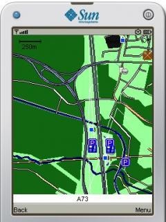
# In normal state the basic GPS data are displayed. Additionally the total number of POIs and the number of POIs in the cache are indicated. During the cache initialization appears the message "init.". The time the cache initialization takes, gives a clue about the CPU power of the mobile phone. If "init." does not disappear, the mobile phone is too slow.
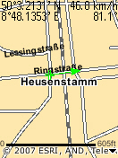
The indication takes place in blue, if no connection to the GPS receiver exists and red, if the GPS data are invalid (no free view to satellites).
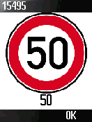
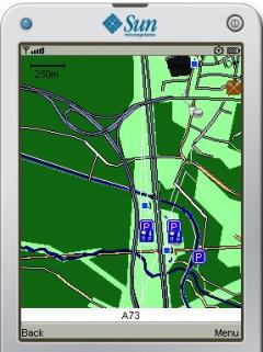
# During approach to one or more POIs the appropriate voice output takes place and the corresponding symbol is indicated. Depending on the type of the mobile phone the display flashes additionally. In the title bar the POI IDs are displayed. Below the symbol the type of the POI is shown. This allows a better distinction than only by symbols and sound.
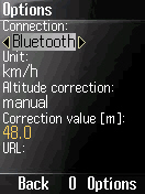
# The menu "Options" contains the following setting possibilities:
License key - License key for use after the test phase
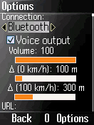
Connection - "Bluetooth", "Cable", "Network/Internal", or "none". With "none" no GPS data are read, makes sense during data import.
Baud rate - Baud rate of the serial interface (NMEA default value 4800 Bit/s)
Illumination - Lighting level of the device's backlight
Voice output - Voice output if on, otherwise jingle
Volume - Volume of the voice output
(0 km/h) - Distance to the next POI, at which alarm takes place at 0 km/h
(100 km/h) - Distance to the next POI, at which alarm takes place at 100 km/h
URL - URL of the connection to the GPS receiver (informative only)
Folder - Full path of the folder Data inbox (informative only)
The distance to the nearest POI, below which the user is alerted, can be adjusted speed-dependently with the options. The faster the vehicle moves, the rather a warning appears (linear correlation).
Push the "OK" button to save the options. If this function is not directly accessible on a function button, it hides behind the button "Options."
POI Data
So that POIAlert can function, first POI data must be imported. At present POIAlert supports files in the formats Map Monkey and Google Earth.
The data of the European stationary speed and red light cameras in these booth formats can be downloaded for free from SCDB.info. For that just a registration is required.
As an alternative data source the POI database of the NaviFriends is supported. It contains also mobile speed traps. But they are not updated on a daily basis. A free registration is required as well.
Both providers support the selection of the desired countries before the download. Due to the long duration of the file import, only the really required countries should be selected.
With conversion the POIs from pocketnavigation.de can be used too.
POI data of non-European countries can be found in several formats e.g. at the GPS Data Team. If the format of the desired file is not supported, a format conversion can be taken into account. In particular a conversion of a CSV (Comma Separated Values) format into the Map Monkey format can easily be done. For a conversion into the Google Earth Format the program PoiEdit can be valuable.
Map Monkey Format
The Map Monkey Format is a simple CSV format. Due to the simple structure the file import is faster, than with the Google Earth format, and it needs less memory. For the first tests therefore this format is recommended.
However the data from SCDB.info contain in the column Type only the value MANUAL. Therefore combined cameras for speed and red light or cameras with variable speed limit cannot be indicated as such. For a non zero speed value the related speed limit sign will be indicated. Otherwise the traffic light sign appears.
ASC files of the NaviFriends can be converted with the Excel macro NaviFriends_makro.zip into the Map Monkey format. With the converted file all camera types are indicated correctly.
Google Earth Format
The Google Earth format (KML) is a XML format (eXtended Markup Language). Since the several fields are used differently by the POI providers, the import functionality has to be adapted specifically for each provider.
The SCDB.info download file has an extension of "kmz". This is a ZIP file. The file must be unzipped and afterwards copied to the Data inbox directory on the mobile phone.
The file google_earth_Blitzer.kml from the NaviFriends can be imported directly.
POIs from pocketnavigation.de can be converted with the program PoiEdit into the Google Earth format and afterwards be imported.
For technical reasons the actual progress during the import of Google Earth files can be indicated only by the counter. Instead of the progress bar appears an animation, which depends on the type of the mobile phone.
· 15 days trial
What's New in This Release:
· Workaround for Sonim devices et al.
What's New in 1.6.1:
· Manual altitude correction for internal GPS receivers, Bluetooth URL editable.


Comments not found