


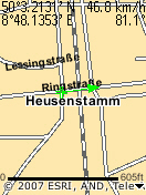
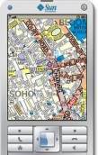
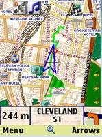
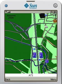
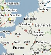
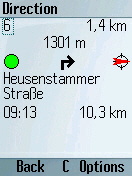
LocViewer - loads map sections according to the current position from a Web service from the Internet and indicates the position on the display of the mobile phone. As data source e.g. road maps or satellite photos can be selected. In addition the speed and the moving direction are indicated. The map sections can be panned and zoomed.
In order to reduce data traffic, the map sections are stored in the mobile phone. So a map section must be downloaded only once.
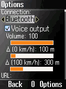
LocViewer runs on all phones which support at least CLDC 1.1 and MIDP 2.0 and allow access to Bluetooth (JSR 82) or the serial interface (data cable). That applies to nearly all current mobile phone models. Alternatively an integrated GPS receiver can be used if it can be accessed using JSR 179.
GPS receivers with Bluetooth or serial interface are supported, which provide the NMEA 0183 sentences GGA and VTG or RMC. That nearly all at the market available might be.
In the connection mode "Network/Internal" the Location API (JSR 179) is used. In this case no external GPS receiver is needed. In this case the location is determined by the GPS receiver or by the network provider. This functionality is obviously supported however in Germany so far by no provider.
LocViewer can load maps from Google Maps, Yahoo! Maps from the specified data source and whose coordinates smaller or larger than the specified once will be deleted than.
LocViewer Pro offers the following capabilies beyond the function range of LocViewer:
- a direction arrow in the map display, whose length changes speed-dependently,
- storage of waypoints,
- import of waypoints from and export into GPX files,
- sending of the current position by SMS,
- logging of the raw NMEA data into a file,
- sending of the current position to an server in the Internet.
For file access the mobile phone must support additionally JSR 75 or the proprietary Siemens way. For the sending of the postion by SMS JSR 120 is required.
GPX files (GPS Exchange format) have become a pseudo standard for the exchange of waypoints. GPX files can be converted into many other formats (e.g. see GPSBabel). Currently LocViewer Pro supports the GPX 1.1 Schema. If files are stored in GPX 1.0 Schema, GPSBabel can be used for the conversion too.
GPX files can contain several waypoints, routes, or tracks. A route is an ordered list of waypoints, which represents intermediate stops to a final destination. A track is in contrast an ordered list of points, which describe a path. Tracks usually contain a lot of points. That is why they might exceed the processor power of the mobile phone. Internally in LocViewer Pro waypoints are administered generally in routes.
· 3 days trial
What's New in This Release:
· Workaround for Sonim devices et al.
What's New in 2.1.2:
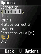
· Manual altitude correction for internal GPS receivers, Bluetooth URL editable.
_programView.jpg)
_programView.jpg)
_programView.jpg)
_programView.jpg)


Comments not found